Appalachian Trail

A Discover-North America Series Achievement
The Appalachian Trail starts at Springer Mountain in Georgia and finishes at Mount Katahdin in Maine. It passes through the states of Georgia, North Carolina, Tennessee, Virginia, West Virginia, Maryland, Pennsylvania, New Jersey, New York, Connecticut, Massachusetts, Vermont, New Hampshire, and Maine. The majority of the trail is in the wilderness, although some portions traverse towns, roads, and cross rivers.
I have to highly recommend the book “A Walk in the Woods.” Bill Bryson tells a very funny story about hiking the AT. It is also a movie with Nick Nolte and Robert Redford. Bill Bryson writes, “Distance changes utterly when you take the world on foot. A mile becomes a long way, two miles literally considerable, and ten miles whopping.”
[DTP] Tom SWFL
It’s a great reflection on how everything feels longer on foot!
Please join us for some Low and Slow flying through mountains, rivers, and valleys.
We are going to take this adventure to the air.
Hey, it’s better than walking!
*** Earn your next DigitalThemePark achievement ! ***
What: Appalachian Trail Achievement Flights
When: Sundays, starting Jul 12th, 8am PT, 11am ET, 1500 UTC
Where: Discord
Additional Info: www.digitalthemepark.com
LittleNavMap route files <click here to download>
Flight Route (Click on map to expand)
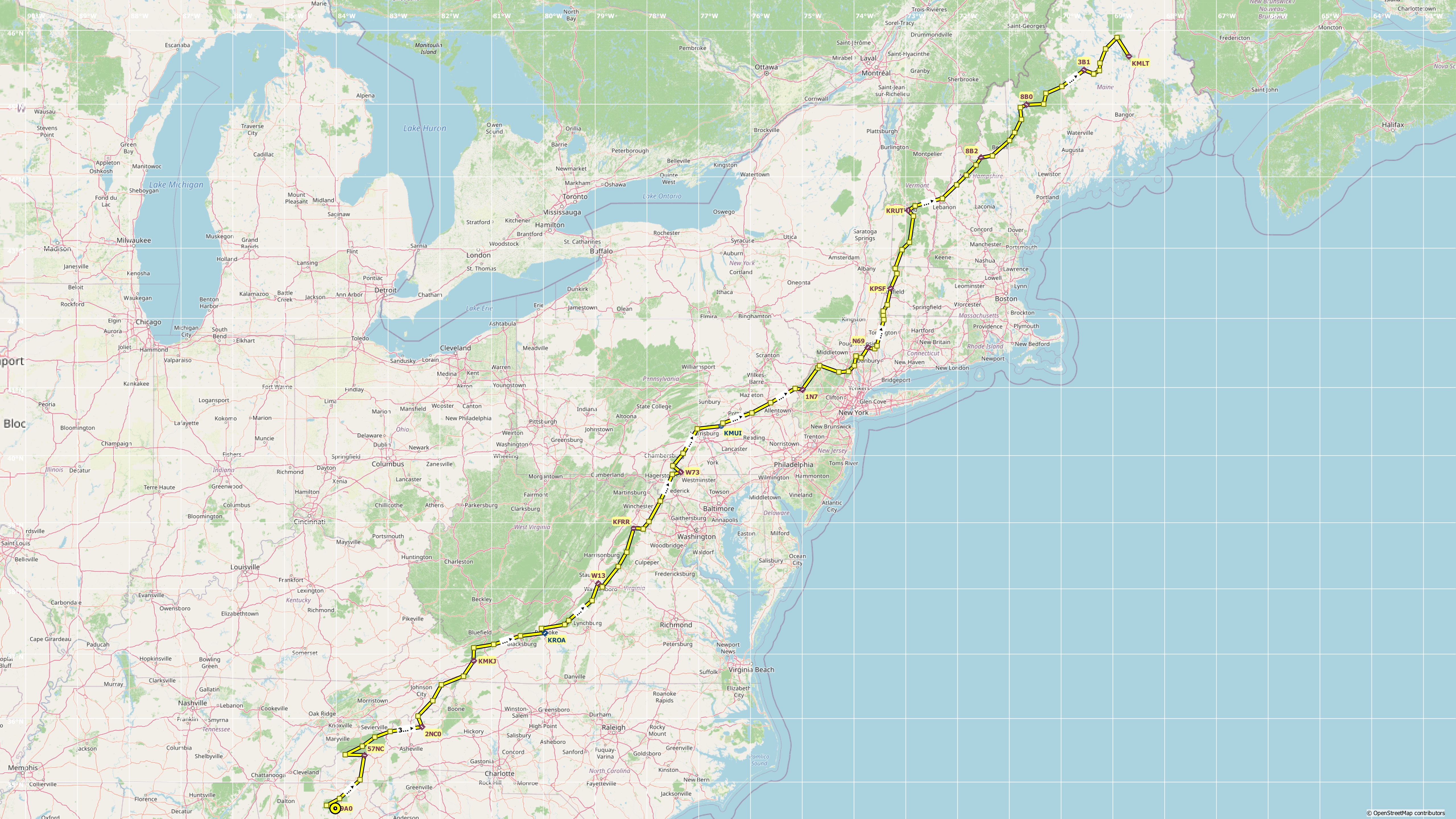
- Lumpkin Co-Wimpy’s (9A0) to Sossamon Field (57NC) – 74 nm
- Sossamon Field (57NC) to Mountain Air (2NC0) – 96 nm
- Mountain Air (2NC0) to Mountain Empire (KMKJ) – 85 nm
- Mountain Empire (KMKJ) to Roanoke-Blacksburg Rgnl Woodru (KROA) – 79 nm
- Roanoke-Blacksburg Rgnl Woodru (KROA) to Eagle’s Nest (W13) – 76 nm
- Eagle’s Nest (W13) to Front Royal-Warren Co (KFRR) – 66 nm
- Front Royal-Warren Co (KFRR) to Mid-Atlantic Soaring Center (W73) – 71 nm
- Mid-Atlantic Soaring Center (W73) to Muir AAF (KMUI) – 69 nm
- Muir AAF (KMUI) to Blairstown (1N7) – 80 nm
- Blairstown (1N7) to Stormville (N69) – 83 nm
- Stormville (N69) to Pittsfield Mun (KPSF) – 61 nm
- Pittsfield Mun (KPSF) to Rutland – Southern Vermont Rgn (KRUT) – 73 nm
- Rutland – Southern Vermont Rgn (KRUT) to Twin Mountain (8B2) – 77 nm
- Twin Mountain (8B2) to Bean Mun (8B0) – 64 nm
- Bean Mun (8B0) to Greenville Mun (3B1) – 59 nm
- Greenville Mun (3B1) to Millinocket Mun (KMLT) – 63 nm
Recommendations
- Simulator: Microsoft Flight Simulator
- Aircraft: Small GA Single/Twin or Helicopter
To get credit for our flights, please adhere to the following rules
- Fly during sponsored events or with two or more pilots online.
- Up to four flight legs a week across all DTP achievements.
- Real Weather / Real Time / Real Charts / No Slewing / No Time Compression.
- Any aircraft and form of navigation allowed.
- If unable to complete a flight, land and save the flight.
As always, meet us on Discord for more event details.
Categories
Achievement Flights, Discover-North America, Flight Division
